
Thèse de Boualem Bouyahiaoui
La marge orientale dans la région d’Annaba a fait l’objet de la thèse de Boualem Bouyahiaoui dont le manuscrit est ici, et d’une publication dont le pdf est ici. Les résumés de la publication (1) et de la thèse (2) synthétisent les principaux résultats obtenus sur cette zone d’étude :
(1) Bouyahiaoui, B., F. Sage, A. Abtout, F. Klingelhoefer, K. Yelles-Chaouche, P. Schnurle, A. Marok, J. Déverchère, A. Rahmani, A. Galve, and J.Y. Collot (2015), Crustal structure of the eastern Algerian margin and adjacent deep basin, implications for late Cenozoic geodynamic evolution of the western Mediterranean, Geophys. J. Intern., 201, 1912–1938, doi:10.1093/gji/ggv102.
SUMMARY
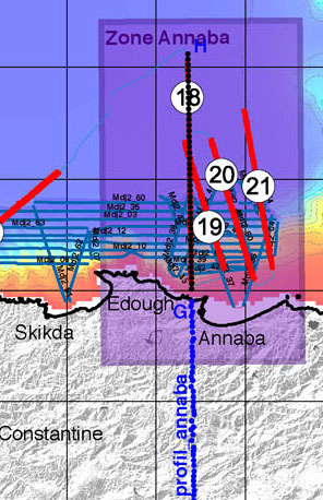
We determine the deep structure of the eastern Algerian basin and its southern margin in the Annaba region (easternmost Algeria), to better constrain the plate kinematic reconstruction in this region. This study is based on new geophysical data collected during the SPIRAL cruise in 2009, which included a wide-angle, 240-km-long, onshore–offshore seismic profile, multichannel seismic reflection lines and gravity and magnetic data, complemented by the available geophysical data for the study area. The analysis and modelling of the wide-angle seismic data including refracted and reflected arrival travel times, and integrated with the multichannel seismic reflection lines, reveal the detailed structure of an ocean-to-continent transition. In the deep basin, there is an ∼5.5-km-thick oceanic crust that is composed of two layers. The upper layer of the crust is defined by a high velocity gradient and P-wave velocities between 4.8 and 6.0 km s−1, from the top to the bottom. The lower crust is defined by a lower velocity gradient and P-wave velocity between 6.0 and 7.1 km s−1. The Poisson ratio in the lower crust deduced from S-wave modelling is 0.28, which indicates that the lower crust is composed mainly of gabbros. Below the continental edge, a typical continental crust with P-wave velocities between 5.2 and 7.0 km s−1, from the top to the bottom, shows a gradual seaward thinning of ∼15 km over an ∼35-km distance. This thinning is regularly distributed between the upper and lower crusts, and it characterizes a riftedmargin,which has resulted from backarc extension at the rear of the Kabylian block, here represented by the Edough Massif at the shoreline. Above the continental basement, an ∼2-km-thick, pre-Messinian sediment layer with a complex internal structure is interpreted as allochthonous nappes of flysch backthrusted on the margin during the collision of Kabylia with the African margin. The crustal structure, moreover, provides evidence for Miocene emplacement of magmatic intrusions in both the deep basin and the continental margin. Based on the crustal structure, we propose that the eastern Algerian basin opened during the southeastward migration of the European forearc before the collision, along a NW–SE elongated spreading centre that ran perpendicular to the subduction trend. Such an atypical geometry is explained by the diverging directions of the subduction rollback during the backarc opening : eastward for the Corsica–Sardinia block, and southward for the Kabylian blocks. This geometry of the forearc can be interpreted as the surface expression of a slab tear at depth, which is responsible for atypical magmatism in the overlying backarc oceanic basin.
Key words : Tomography ; Composition of the oceanic crust ; Continental margins ; divergent ; Africa.
(2) Bouyahiaoui, B. (2014), Structure profonde et réactivation de la marge est-algérienne et du bassin adjacent (secteur d’Annaba), contraintes par sismique réflexion multitrace et grand-angle terre-mer, Doctorat d’université en Sciences de la Terre de l’Université Nice Sophia Antipolis, co-tutelle USTHB et CRAAG Alger - UNS Nice, 308 pp.
https://tel.archives-ouvertes.fr/tel-01134669
Résumé
Dans ce travail de thèse, nous analysons la structure crustale de la marge est-algérienne et du bassin adjacent (région d’Annaba), à partir d’un ensemble de nouvelles données géophysiques acquises durant le programme SPIRAL « Sismique Profonde et Investigation Régionale du nord de l’Algérie ». La campagne d’acquisition, réalisée en 2009, a permis d’acquérir, dans la région d’Annaba, un profil sismique terre-mer de 240 km de long, des lignes sismiques réflexion pénétrante 360-traces, et des profils gravimétriques et magnétiques. Nous disposons par ailleurs, pour cette étude, de données supplémentaires incluant notamment un ensemble de profils de sismique réflexion offrant des résolutions complémentaires.
La structure crustal ainsi établie nous permet de discuter les nombreux modèles cinématiques d’ouverture du bassin est-algérien proposés dans la littérature, afin de caler dans le temps la formation du bassin par rapport à la collision. La deuxième partie de ce travail consiste à localiser la déformation liée à la réactivation de la marge, par rapport aux grands domaines lithosphériques du système marge-bassin, afin de mieux comprendre les modalités de l’inversion.
A partir de la structure crustale et des anomalies magnétiques du bassin profond, nous proposons que le bassin est-algérien se soit ouvert à l’arrière de l’arc européen durant la migration vers le sud-est de ce dernier, un modèle d’évolution géodynamique est ainsi proposé. L’analyse des profils de sismique réflexion aux différentes résolutions montre que la déformation crustale récente liée à la réactivation de la bordure nord-algérienne se localise essentiellement au niveau de la zone de striction de la croûte continentale.
Mots-clés : Méditerranée occidentale, marge Algérienne, structure profonde, déformation, structure active, subduction, méthodes sismiques.
ملخص
قمنا في هذه الأطروحة بتحليل بنية القشرة الأرضية لحاشية الشرق الجزائري وحوضه المجاور (منطقة عنابة)، استنادا من مجموعة من معطيات جيوفيزيائية جديدة
مكتسبة خلال برنامج "سبيرال". تمّ قياس هذه المعطيات سنة 2009 والمتمثلة في : مظهر زلزالي كبير الزاوية يبلغ طوله 240 كيلومتر وخطوط زلزالي
قمنا في هذه الأطروحة بتحليل بنية القشرة الأرضية لحاشية الشرق الجزائري وحوضه المجاور (منطقة عنابة)، استنادا من مجموعة من معطيات جيوفيزيائية جديدة
مكتسبة خلال برنامج "سبيرال". تمّ قياس هذه المعطيات سنة 2009 والمتمثلة في : مظهر زلزالي كبير الزاوية يبلغ طوله 240 كيلومتر وخطوط زلزالية انعكاسية
مخترقة و وخطوط ملامح الجاذبية والمغناطيسية. إلى جانب هذه المعطيات، تمّ ضمّ معطيات إضافية. سمحت لنا بنية القشرة الأرضية المنشأة بمناقشة العديد من
النماذج الحركية المقترحة لنشأة حوض الشرق الجزائري. وهذا من أجل تثبيت نشأته في الزمن بالنظر إلى تلاحم الكتلة الاوروبية مع القارة الأفريقية. الجزء الثاني
من هذه الأطروحة يتمثل في تحديد مكان التشوهات الناجمة من تنشيط الحاشية وتمركزه بالنسبة الى المناطق الرئيسية للغلاف الصخري لنظام حاشية – حوض،هذا
من أجل فهم شروط الانقلاب.
انطلاقا من مكونات القشرة الأرضية والشذوذ المغناطيسي للحوض العميق، نقترح في هذه الأطروحة أن حوض الشرق الجزائري تمّ نشأته خلال هجرة القوس
الأوروبي نحو الجنوب الشرقي قبل إلتحامه مع القارة الأفريقية. وتبرهن تحليل الخطوط الزلزالية الإنعكاسية أن تشوهات القشرة الحديثة تتمركز أساسا في منطقة
المعانقة، هذه التشوهاتة انعكاسية
مخترقة و وخطوط ملامح الجاذبية والمغناطيسية. إلى جانب هذه المعطيات، تمّ ضمّ معطيات إضافية. سمحت لنا بنية القشرة الأرضية المنشأة بمناقشة العديد من
النماذج الحركية المقترحة لنشأة حوض الشرق الجزائري. وهذا من أجل تثبيت نشأته في الزمن بالنظر إلى تلاحم الكتلة الاوروبية مع القارة الأفريقية. الجزء الثاني
من هذه الأطروحة يتمثل في تحديد مكان التشوهات الناجمة من تنشيط الحاشية وتمركزه بالنسبة الى المناطق الرئيسية للغلاف الصخري لنظام حاشية – حوض،هذا
من أجل فهم شروط الانقلاب.
انطلاقا من مكونات القشرة الأرضية والشذوذ المغناطيسي للحوض العميق، نقترح في هذه الأطروحة أن حوض الشرق الجزائري تمّ نشأته خلال هجرة القوس
الأوروبي نحو الجنوب الشرقي قبل إلتحامه مع القارة الأفريقية. وتبرهن تحليل الخطوط الزلزالية الإنعكاسية أن تشوهات القشرة الحديثة تتمركز أساسا في منطقة
المعانقة، هذه التشوهات مرتبطة بتنشيط حافة الشمال الجزائري.
الكلمات المفتاحية : البحر الأبيض المتوسط الغربي، الحاشية الجزائرية، البنية العميقة، تشوهات القشرة الأرضية، البنية الناشطة، منطقة الإندساس، الطرق
الزلزالية.